Mysteries of the Hopewell by William F. Romain
Author:William F. Romain
Language: eng
Format: mobi, epub
ISBN: 9781931968041
Publisher: The University of Akron Press
Published: 2013-02-19T17:38:20+00:00
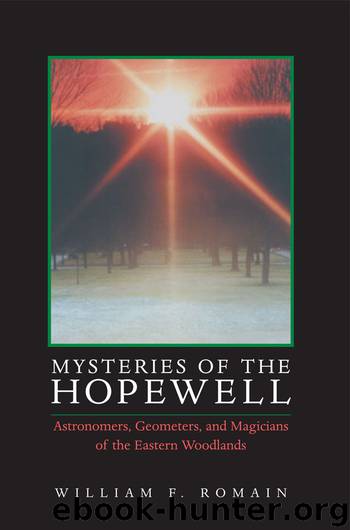
Fig. 4.24. Winter solstice sunset in alignment with the Marietta Sacra Via. Photo by the author, December 21, 1996.
Figure 4.24 shows the alignment as it occurred on that cold day in December. But a photograph alone cannot sufficiently convey the sense of awe or wonder that overtakes a solitary witness to the moment when the sun, ever so gently, touches the horizon in alignment with an ancient earthwork. At that moment, time almost seems to stop as the warm solar energy pulses and races across the landscape and into the heart of the ancient figure. As the sun’s rays enter through the sacred passageway, it seems as though everything within the boundary of the geometric figure is suddenly charged and revitalized with the life force of the sun. Is it too much to think that maybe the Hopewell recognized the same thing?
As I drove home that night, the implications of what I witnessed began to dawn on me. A quick look at the Curtis map showed that the southwest facing wall of the Large Square was built perpendicular to the Sacra Via. As a result, the Large Square itself was oriented to the winter solstice sun. That is, the minor axis of the Large Square was oriented along the same azimuth as the Sacra Via, which is aligned to the winter solstice sunset.
Actually, I was hardly aware of the long drive home as yet another pattern in the data began to emerge. Yes, I had just verified that the Sacra Via or parallel walls at Marietta were aligned to the winter solstice sunset. But then I remembered that the same winter solstice alignment is also found in the long parallel walls at Hopeton. Later, I could barely contain my excitement when I realized that, like Marietta and Hopeton, the long parallel walls at Fort Ancient are also aligned to the winter solstice sunset.
My findings relevant to Fort Ancient are based on my analysis of Robert Connolly’s map of the Fort Ancient site (Connolly 1997: fig. 10.2) which shows the parallel walls to extend along an azimuth of 237°.0. Because of agricultural plowing, the Fort Ancient parallel walls are not very visible at ground level. However, Connolly successfully located the walls through extensive excavations and soil core sampling. By reference to features shown both on the USGS topographic map for the area and Connolly’s map, I was able to determine that Connolly’s map used true north as its reference. By actual field survey, I was further able to establish that the horizon elevation along the 237°.0 sightline, as measured from within where the parallel walls were located, is 1°.5.
Using a date of A.D. 250, 39°20’ north latitude, lower limb tangency, and 1°.5 horizon elevation, it is found from Aveni’s tables that the winter solstice sun set at an azimuth of 237°.3778. The Fort Ancient parallel walls therefore, are aligned to the winter solstice sunset to within about one-third of one degree (237°.3778 – 237°.0 = 0°.3778).
In other words, the parallel walls
Download
Mysteries of the Hopewell by William F. Romain.epub
This site does not store any files on its server. We only index and link to content provided by other sites. Please contact the content providers to delete copyright contents if any and email us, we'll remove relevant links or contents immediately.
| Africa | Americas |
| Arctic & Antarctica | Asia |
| Australia & Oceania | Europe |
| Middle East | Russia |
| United States | World |
| Ancient Civilizations | Military |
| Historical Study & Educational Resources |
Cat's cradle by Kurt Vonnegut(15481)
Pimp by Iceberg Slim(14724)
4 3 2 1: A Novel by Paul Auster(12554)
Underground: A Human History of the Worlds Beneath Our Feet by Will Hunt(12184)
The Radium Girls by Kate Moore(12126)
Wiseguy by Nicholas Pileggi(5881)
The Fire Next Time by James Baldwin(5542)
Perfect Rhythm by Jae(5505)
American History Stories, Volume III (Yesterday's Classics) by Pratt Mara L(5354)
Paper Towns by Green John(5269)
Pale Blue Dot by Carl Sagan(5104)
A Higher Loyalty: Truth, Lies, and Leadership by James Comey(5044)
The Doomsday Machine by Daniel Ellsberg(4583)
The Mayflower and the Pilgrims' New World by Nathaniel Philbrick(4579)
Killers of the Flower Moon: The Osage Murders and the Birth of the FBI by David Grann(4499)
The Sympathizer by Viet Thanh Nguyen(4470)
Too Much and Not the Mood by Durga Chew-Bose(4415)
The Borden Murders by Sarah Miller(4411)
Sticky Fingers by Joe Hagan(4279)
