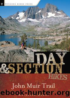
John Muir Trail by Kathleen Dodge
Author:Kathleen Dodge
Language: eng
Format: epub
ISBN: eBook ISBN: 9780897327701
Publisher: Menasha Ridge Press
Published: 2007-03-14T16:00:00+00:00
GPS coordinates Starting trailhead Tuolumne Meadows Wilderness Permit Center
UTM zone (WGS84) 11S
Easting 0293669
Northing 4194684
Latitude N 37°52â²33.15â³
Longitude W 119°20â²59.53â³
GPS coordinates Ending trailhead Redâs Meadow Campground
UTM zone (WGS84) 11S
Easting 0316834
Northing 4165592
Latitude N37°37â²9.14â³
Longitude W 119°04â²21.91â³
From the Tuolumne Meadows Visitor Center (8,630 feet), meander east on a level, dusty trail, passing signs for the backpackerâs campground and a trailhead for Elizabeth Lake. After 0.5 miles of walking, cross a bridge over the Dana Fork of the Tuolumne River. Shortly thereafter a second bridge takes you over the Lyell Fork. After about 2.5 easy miles, traverse rushing Rafferty Creek on a handsome footbridge (8,720 feet) and begin a beautiful stroll in and out of forest thickets and along the grassy expanse of Lyell Canyon as the trail parallels the Lyell Fork of the Tuolumne River. The area is named for Charles Lyell, a 19th-century lawyer turned geologist and good friend of Charles Darwin.
Up until the mid-1800s and the explosion of silver prospectors and explorers, only Native Americans enjoyed the beauty of this region. Miwok and Mono Indians stopped in the area to trade during the summer en route east. These days, though, visitors from around the world come to marvel at the landscape. Rainbow trout lure anglers to this stretch of Yosemite from late April through mid-November.
The trailâs proximity to busy Tuolumne Meadows, as well as its level grade, nearly guarantees that you will have company in this part of the wilderness. The presence of hikers careless with their food, combined with shallow waters teeming with fish, also means that this is popular bear and deer country. Be sure to keep your snacks and food secure at all times. Camping is prohibited within the first 4 miles from Tuolumne Meadows. Bear canisters are essential here, and there is no question that you will lose your food if you donât have one.
After crossing Rafferty Creek, reach the next trail junction in a little more than 4 miles at the turnoff (8,900 feet) for Ireland Lake, savoring views of the Unicorn and Mammoth peaks along the way. Shortly after passing this trail juncture, encounter Potter Point and numerous campsites. Ahead, glimpse Mount Lyell, the parkâs highest peak at 13,114 feet, and Donahue Pass beckoning in the distance.
About 8 miles from the visitor center, the trail turns away from the river and begins the initial climb toward Donahue Pass, passing a well-used camping area. Dubbed Lyell Fork Base Camp (9,040 feet), this area is popular with local backpackers and sees quite a bit of use in the summer months. Initially the climb is in a shaded pine bench, and then it evolves into steeper exposed switchbacks with fantastic views back toward the valley. After 1.5 miles, the trail flattens for a bit and reaches a bridge over the Lyell Fork (9,650 feet). There are camping sites on either side of this sturdy footbridge. After crossing the river, begin climbing again, sometimes quite steeply, up a rocky set of switchbacks. Your prize is a stunning
Download
This site does not store any files on its server. We only index and link to content provided by other sites. Please contact the content providers to delete copyright contents if any and email us, we'll remove relevant links or contents immediately.
Giovanni's Room by James Baldwin(7351)
The Plant Paradox by Dr. Steven R. Gundry M.D(2627)
The Stranger in the Woods by Michael Finkel(2538)
Miami by Joan Didion(2370)
Wild: From Lost to Found on the Pacific Crest Trail by Cheryl Strayed(2267)
INTO THE WILD by Jon Krakauer(2203)
Trail Magic by Trevelyan Quest Edwards & Hazel Edwards(2186)
DK Eyewitness Top 10 Travel Guides Orlando by DK(2180)
Vacationland by John Hodgman(2135)
The Twilight Saga Collection by Stephenie Meyer(2131)
Nomadland by Jessica Bruder(2069)
Birds of the Pacific Northwest by Shewey John; Blount Tim;(1976)
The Last Flight by Julie Clark(1967)
Portland: Including the Coast, Mounts Hood and St. Helens, and the Santiam River by Paul Gerald(1932)
On Trails by Robert Moor(1904)
Deep South by Paul Theroux(1839)
Blue Highways by William Least Heat-Moon(1779)
Trees and Shrubs of the Pacific Northwest by Mark Turner(1726)
1,000 Places to See in the United States and Canada Before You Die (1,000 Places to See in the United States & Canada Before You) by Patricia Schultz(1654)
